Monday, April 18, 2022

April 18,2022: Belated 10th Anniversary Tour (thanks Covid) to Northern New Mexico. FIRST STOP FARMINGTON


 “When I got to New Mexico that was mine. As soon as I saw it that was my country. I’d never seen anything like it before, but it fitted to me exactly. It’s something that’s in the air – it’s different. The sky is different, the wind is different.”  ---Georgia O'Keefe


This story really begins 8 or 9 years ago when we were driving to Taos and we passed a sign that said, Ojo Caliente. Paul didn't speak much Spanish at the time beyond Gracias and enchilada, so I told him it meant "warm eye." We looked it up and found that it was a natural hot springs with a spa. We kept passing the sign and eventually resolved to go there, but in winter or early spring, as New Mexico gets a bit hot for warm baths later in the year. Fast forward to February 2019, shortly before the pandemic put travel to a halt. We made our reservations, packed our bags, and set off from Albuquerque late in the afternoon to see and experience Ojo Caliente...only to encounter a humdinger of a snowstorm that prevented our progress any further than Santa Fe, and that only with difficulty. The next day, the main highway was cleared of snow, but secondary roads were not. We went South instead. 

We missed it then. And now that travel is opening up, we thought Ojo Caliente deserved a second attempt. And as long as we were in the area, the Four Corners area has some pretty fascinating features worth tapping into. 

The trip to the area in itself is an interesting journey into history and geography. Highway 550 passes numerous historical spots on the way to our goal of Farmington as a base: Coronado and Jemez Historic sites, the Navajo reservation and many small nondescript towns there since the 1800s or even longer. 

The journey takes place at 5000+ feet and passes through multicolored mesas and washes. Much of it is dry and scrubby and gets only 3-4 inches of rain per year. 

Lake Farmington

    On our way in to our Airbnb casita rental, we decided to take a nice walk and circumnavigate Lake Farmington, a 250 acre lake serving as recreation for quite a few families this Easter. It's a popular spot for fishing, kayaking and picnicking. The path was just about 4 miles total and didn't have any extremes of elevation, but it was quite pretty. Wildlife was confined to snakes, ducks and children going nuts next to the water :) 

     From here, we went to our Airbnb. It's small but comfortable and all we need when most of our time will be spent outdoors exploring. 

I'm a sucker for an Airbnb with a GAS stove and attached laundry!

     We got a good night's sleep and then we were off to make the most of TAX DAY and also International Juggling Day!

     We started at Aztec Ruins National Monument.


     The name is a misnomer, as there were NO AZTEC ruins here. But they were built by ancient Puebloan peoples between the 12th and 13th centuries. They were occupied for about 200 years and then the ancient peoples, who believed they exited from the navel of the earth to perform a journey, continued their pilgrimage onward. Much of this ancient pueblo was restored by the work of archeologist, Earl Morris shortly after the turn of the 20th century. The park has a 0.5 mile paved path around partially excavated structures built by a conglomeration of Native American nations and that probably served commercial, religious and ceremonial purposes.

A look at the site which houses numerous buildings made of wood and stone. Wood was carried for more than 20 miles and stones were quarried from about 3-5 miles away by Puebloan peoples without any modern transport.

A look at the structures, the plaza and the Great Kiva (more on that later.)

There was internal ventilation and connecting doors. There were many rooms and although and they weren't believed to originally be intended as residences, it appears they were eventually used as living space. 

A look at the beautiful stone work. There is a ribbon of green stones that run at a single level of the building. Roof support is via logs and dendrochronology has been used to date the structures. 


    It's hard to get a photo that does this ancient place justice. Morris and archeologists reconstructed the Great Kiva they found on the grounds in the center of the plaza and it gives insight into the ceremonial lives of the ancient Puebloans whose ancestors still believe the Aztec Ruins are a sacred place. They say the ancients did NOT desert the structures and that they still move among them.

The reconstructed Great Kiva. You can see the plaza beyond and some of the other buildings.

Entrance to the Kiva. Morris tried to reproduce the paint colors he saw on the premises.

The inside of the Kiva. There is a place for a ceremonial fire. 

The roof is well constructed with ventilation. 

This area which is on a dais above the kiva floor has undetermined purpose.

     The modern tribes of Hopi, Zuni, Acoma, Zia and Navajo are descendants of the Puebloan ancestors. They still hold ceremonies here. The site was abandoned by all but the spirits of these people about 900 years ago for unknown reasons---possibly drought, as they farmed the land at the nearby Animas River. There is great information at the Visitor Center as well as some artifacts from the site, helpful rangers, a short film about the site, souvenirs and brochures. The visitor center is the former home of archeologist, Earl Morris.

This is one of a very nice pottery exhibits in the visitor center.

We had fun watching prairie dogs on the grounds. 

Yep. The sky was very Georgia O'Keefe above the Aztec Ruins.

There is a walk from the Visitor Center across the Animas River. At one time you could walk into the town of Aztec, but at the moment, they are improving the walkway and the downtown isn't accessible. 


     For birdwatchers, we did get to see and hear white-crowned sparrows flitting about the juniper and scrubs. 


    From here, what else but a trip to The Four Corners Monument, the only location in the USA where four states come together in one spot. It is located on the Navajo nation and operated by Native Americans. The entrance fee is $5 per person. There's not much there, but there are some small food stands and souvenir booths in addition to the novelty of this unique geographic phenomenon and its marker. There are some hiking trails for the more adventurous amongst us!
Looking off into Utah. The Horse Tail hiking trail bisects this photo.

The view into Colorado

Paul standing pretty much in New Mexico, Utah, Colorado and Arizona at the same time. 

The entrance to Four Corners Monument
     

     On the way to the monument, you can't help but notice all the mesas in different colors and the dips and washes, native American villages and horses roaming around the brush. You also can't miss Shiprock. There is a town of the same name, but the rock itself rises stark out of an even starker landscape and attracts the eye for many miles. 

Shiprock rises out of the landscape like a cathedral or a fairy castle. It's hard to keep your eyes off of it.


     Our last act of a long but fun and interesting day was a walk along the Animas river. We saw many duck species, Canada goose and an All Wars Veteran's Memorial. The locals use it for recreation: walks, biking and picnics. 

Paul on a bridge across the Animas River. Three Rivers meet in Farmington: Animas, LaPlata and the San Juan.

Duck prints.

The Animas River at nearly sunset.

   There is an oil well in the Animas River recreation park. We learned while driving and from this park exhibit that this area of New Mexico is very rich in oil and gas fields with over 110,000 wells currently in service. 

    If you are traveling this way, we recommend a stop in Farmington, particularly the Aztec Ruins. And for great New Mexico cuisine, the Chili Pod downtown is totally worth your time. 


"Chili is not so much food as a state of mind. Addictions to it are formed early in life and the victims never recover." -------Margaret Cousins

Paul's Ponderings:  Fantastic day out in New Mexico.  Despite having spent tons of time out here over the past 20+ years, I've never been to Farmington or these ruins near here.   The weather today was incredible, starting cool and ending very warm. (From 38 to 83 degrees Fahrenheit!) The Puebloan ruins are amazing, particularly the Grand Kiva....the photos don't do it justice and we had it to ourselves, which was really great.  We ate lunch and dinner both at the Chili Pod, which was outstanding Mexican food.....superb red and green sauce and wonderful fresh food.  We had some lovely walks in the area.....so basically hard to beat this day.   Much more to come.   

Wednesday, November 24, 2021

Bucket List Antarctica (during an eclipse): TIerra del Fuego National Park with birds.

Nothing can be more improving in a young naturalist than a journey to a distant land.

----Charles Darwin

The picturesque Beagle Channel as viewed from Tierra del Fuego National Park. On the second voyage of the Beagle, Captain Fitzroy invited a young naturalist named Charles Darwin. The rest is, as they say, history!


Today, Paul and I were out to see the crown jewel of the area, Tierra del Fuego National Park. As we outlined in a previous blog, Tierra del Fuego is an archipelago of islands owned predominantly by Chile, but in part, by Argentina. The Andes mountains are pretty much all in Chile and the Argentine part is formed by the meeting of the South American and Scotia tectonic plates with Argentina owning the Scotia segment. The National Park comprises parts of both countries, but there are only ROADS in Argentina. Hence, visitors are committed to visiting via Argentina unless going by water.  We were more than happy to head down the road about 12 miles out of Ushuaia with our local guide, Gaston, to visit the park and specifically to see some of the birds. But we got much more than we hoped for! The natural unspoilt beauty here is truly astonishing and cannot be captured in photos, but I tried!


Ruta 3 (AKA the Panamerican Highway) ends in the park. This was our approach.

When you go birdwatching, this is MOSTLY what you see with the occasional addition of a bird! On the other hand, it is good range of motion for your neck. 

The pirate impersonates a serious birdwatcher. He was looking for a pygmy owl--which we heard but never saw despite considerable efforts. 

The water in the Acigami lake is fairly shallow, completely clear and serves as a mirror for the Andes.


Tierra del Fuego National Park is located in southwest Tierra del Fuego and abuts Chile. It covers 68,909 hecateres in the southern tip of the Andes Mountains going from lake Fagnano (see prior blog for a look at this) to the Beagle Channel.  The main island of the archipelago was first occupied by man about 10,000 years ago. The various tribal groups integraed effectively with the local environs that we often would classify as 'hostile.'  The Yamana natives lived on its shores and made camps on the beaches harvesting from the sea. They moved about in canoes, hunted sea lions and harvested the still-abundant mollusks in the area. The extinction of these natives coincided with the migration of the first Europeans in 1890 and is attributed to infectious diseases as well as intentional violence against them. In 1910, there were 100 natives left. So this is the sad tale of the aboriginals here. 

The current inhabitants are very serious about preserving the pristine nature of this park after many years of introductions of non-native species. And we are happy to know their commitment. Such beauty deserves our attention. 

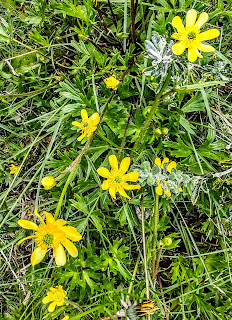
There were many wildflowers in bloom in the Fuegan spring. These were called buttercups.

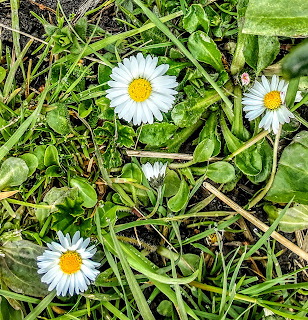
There were fields of daises and many, many dandelions thriving. 

Upland geese were the predominant bird species we saw. 

Holly flowers. 

American tourist stunned by beauty!

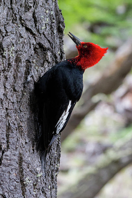
We hiked along the lakes and through the forest searching for birds and just generally enjoying the scenery. We saw many birds, but the crowning glory was the Magellanic woodpecker of which we saw 5,both males and females. 

Fire-eyed Duicon

This is a huge bird. And so beautiful. Magellanic woodpecker.


Forests here are not overly diverse and are made mostly of beech species and a few evergreens, with some low lying bushed called "lengua."

The park has many well marked and maintained trails. 

We did see some wildlife today--- all introduced species though--the grey fox and fat rabbits. We also saw horses, and like the cattle ranging in the USA national parks, there is great controversy as to whether or not they should be allowed to graze there. 

Horse and foal

There were numerous horses seen with Andes as a backdrop. 


Really, we could go on and on about the scenery and the thirty species of birds we saw, but suffice it to say, this was a great weather day with outstanding views and a great walks. 

After our excursion, we visited the southernmost post office in the world and then we went to dinner at a local favorite restaurant, Maria Lola. The specialty there is king crab which was delicious. 


Fin del Mundo post office on the Beagle Channel

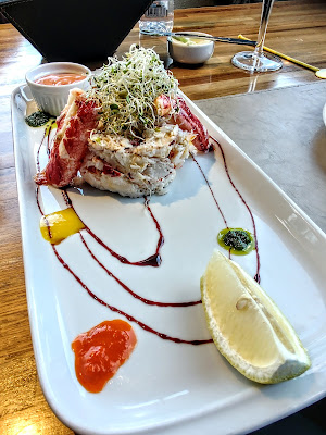
King crab salad made of nothing but king crab. YUM

More food porn. My salmon ravioli!

Paul's seafood linguine


This was a truly amazing day. We are here in springtime and although the weather is ever-changing year round, we would recommend a trip probably best positioned in early or late summer. The flight would be a bit expensive (about $1200-1800 USD) but lodging and food are cheap!


"Among the scenes which are deeply impressed on my mind, none exceed in sublimity the primeval forests undefaced by the hand of man; whether those of Brazil, where the powers of Life are predominant, or those of Tierra del Fuego, where Death and decay prevail. Both are temples filled with the varied productions of the God of Nature: -- no one can stand in these solitudes unmoved, and not feel that there is more in man than the mere breath of his body."
Charles DarwinVoyage of the Beagle


Paul's Ponderings:  What a great day out in Patagonia.   The weather was greatly improved over the past couple of days -- sun and a bit of wind but not too much of the latter.   We saw a huge amount of local birds with our guide Gaston.   At the end of the day, our ship, the Hondius, was visible in the harbor from where we are staying.   We finished the day with a great meal at Cafe Maria Lola.   Mucho gusto!

Tuesday, November 23, 2021

Bucket List Antarctica (during an eclipse): On the Road in Tierra del Fuego

 “For the one who
writes it . . . a story is like a mirror.”

― Sylvia Iparraguirre, Tierra del Fuego


Tierra del Fuego (Land of the Fire named by Magellan) is a large island separated from the South American continent by the Straits of Magellan. What you see in green is Argentine and the rest belongs to Chile. We are located at the tip of the red arrow


We spent the better part of Sunday getting here! The flight is about four hours long from Buenos Aires, but is mostly over ocean and partly over the Andes. It's one of my favorite parts of flying---looking down and seeing the Pampas and rivers and finally, shortly before we landed, just barely below us, the sharp peaks of the Andes covered in snow. Really breathtaking!

We found a nice Airbnb prior to leaving the USA and are making it our home for the next few days. The town of Ushuaia (a native word that means a bay that faces the west) is located on a fairly steep hillside with a flat portion down near the harbor. This is the view from our apartment:
The town of Ushuaia located on a slope coming down from the coastal Andes on the Beagle Channel

Ushuaia is home to about 80,000 people but until the Argentine government started to encourage and subsidize people coming here in the mid-1970s, it was home to only about 3000 people, mostly military and fisherman. 

We took a nice walk around the area.  The military has a big base here at the end of the world. There is an airport and many touristy spots, but it was pretty quiet. The tourist trade has been fairly silent since COVID with the country only opening for foreigners November 1, 2021. We weren't sure we would be allowed to make this very longed for trip. 
Our first dinner with local Jeremy Buttons gin on the Beagle Channel It is light until 10:30pm.

Paul stands at the end of the world. (as we know it) 

This aircraft flew missions to Antarctica and is on display near the Naval Base. 

The Andes descend onto the Beagle Channel with wondrous views of Ushuaia. If you don't like the weather, wait 5 minutes. We experienced a snowstorm with 30mph winds and sunny skies and 45 degrees on the same day. 

A gull wanders amongst the molllusks at low tide 

A memorial on the waterfront to the dead from the Guerra Malvinas (also known as the Falklands War.) The Falklands (malvinas) have a very complex history including Margaret Thatcher trying to give them back to Argentina just a year prior to the conflict But don't try to TAKE them??? It's a sore spot!

An eternal flame and the names of more than 660 war deaths from Argentina, many from Tierra del Fuego. 

The ever present lapwing

The lovely wine we enjoyed at dinner for about $15 from Neuquen province. 

Pizza for dinner? NO surprise there!

Sunrise Ushuaia 4:52 AM


Even with a map and photos, it is hard to describe the topography of the area. The South American plate meets the Scotia plate and that is what separates Argentina from Chile. We got a good idea about it today as we drove around the area between the coast and toward the interior of Tierra del Fuego. 

The Andes, only about 3000 feet in the coast and running east and west instead of north and south here (due to tectonic plate movements) , are located in Chile. We took the photo from the Scotia plate=Argentina Tierra del Fuego.  The Rio Olivas with its peat bogs and red sphagnum moss separates the plates and the countries. 

We visited Lago Fagnano, one of the largest lakes in Argentina. It is 75 miles long, 5 miles wide and roughly the same size as the Beagle Channel. 

Looking down south on the Lake Fagnano

Looking North on Lake Fagnano

There are many signs of beavers in the area----gnawed wood and dams. We didn't see any beavers, although guide books said they "roamed the streets." Beavers were brought in to exploit as part of the fur trade, so that went south literally and figuratively. Argentina, like the USA and many other countries, has practiced numerous harebrained ideas about introducing non-native species. One idea was literally harebrained---they brought in rabbits for food. The sailors carried them on ships because they taste good and reproduce...well, like rabbits. These are now wild and have been a big problem at times. Then they brought in grey foxes to eat the rabbits, but they prefer other rodents, so now they have too many grey foxes which compete with the native red fox. They don't have a lot of wildlife--no deer, elk, bears, etc. Just guanaco, mara and a few other native species. What they do have is birds. We saw these specimens out and about today:

Ashy-headed goose

Chimango caracara--An "opportunist" bird according to our guide. He says opportunistic people also get called "chimangos"

Upland geese: Male and Female

Along the way for our birding and geography tour, we stopped at some very local spots: a training camp for mushing dogs (they had 135 Siberian and Alaskan huskies on site and walked all 135 at once! ) and came back for lunch at their parilla where they roasted a buttload of meat. We had one dinner and it was more than we could eat! It's been a tough year and a half for the tourism industry and the dog mushing business has been low, but they are optimistic .. and they LOVE LOVE LOVE dogs!

Each dog is cared for like family and has its own home. 

135 dogs grace this facility. I wish you could have heard them howling! It was like a doggie choir!

Doggieland has a side gig as the only restaurant in a forever distance. They serve parilla with lamb, beef , chicken and potatoes. 1 order will MORE than serve two people our age. 

So far, we have really enjoyed our time at THE END OF THE WORLD. The vistas cannot be beat. The people are friendly. The dogs are a bit loud, but okay... We enjoyed the local meal including a world class dinner tonight at Kaupe. If you are here, you MUST go there. It's very inexpensive, up on a hill so you can enjoy the Beagle Channel and the lower coastal Andes, and the food is local, outstanding and about 25% the cost of a similar meal in the USA.  
We can't say enough wonderful things about Tierra del Fuego de Argentina and look forward to the national park tomorrow. 

The South American tectonic plate and the Andes. 

Perfectly cooked sea bass from the Antarctic shelf (caught at 1000 meters and "the real sea bass" per the chef who quoted the scientific name and told us that a lot of "seabass" is cooked by liars!)

" A bad review is even less important than whether or not it is raining in Patagonia."
---Iris Murdoch


Paul's Ponderings:  What an incredible area Patagonia is.....the weather really does change about ever 10 minutes as a start!    We landed and it was quite cold and breezy and that continued into the next day.  Quite a change from 90 degrees in Buenos Aires!    That said, it is massively scenic here as the end of the world warrants.   We've been to the tip of Africa, but this is even further south.    And unlike South Africa, it's like Scandinavia here, relatively speaking.

Ushuaia is quite scenic.....we walked around town and it is a combo of rustic and modern.    It's quite unusual for Argentina in general and Chile is just across the Beagle channel.   Amazingly, Charles Darwin came through here as did Magellan!    Quite the history in general.....after Magellan came through it was 300+ years before this area was "discovered".    Magellan called it "Tierra del Fuego" due to seeing the native fires and the name stuck.   And here we area in 2021.   

So far we've had great food, great scenery, a hundred weather changes, and massive good time.  And besides the cost of getting here, it's very affordable.   More to come!